SOURCES OF FLOODING
 The major sources of flooding in Sangamon County are the Sangamon River and the South Fork of the Sangamon River. However, many other creeks including Black Branch, Brush Creek, Buck hart Creek, Cantrall Creek, Clear Creek, Fancy Creek, Horse Creek, Lick Creek, Panther Creek, Polecat Creek, Prairie Creek, Richland Creek, Spring Creek, Sugar Creek, Wolf Creek, and their tributaries as well as Lake Springfield, experience major flooding events.
FLOODING EVENTS
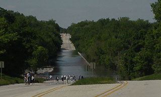
Major flooding events occurred in 1993, 1995, 1996, 2002, 2008, and 2015. In December 2015, major flooding occurred along the South Fork of the Sangamon River, cresting four feet above the 2002 level, and the Sangamon River exceeding the 100-year flood elevation, although not reaching historic 1926 and 1943 crests. Water heights for the Sangamon River and South Fork of the Sangamon River can be monitored at this website http://water.weather.gov/ahps2/index.php?wfo=ilx.
FLOODPLAIN DETERMINATION
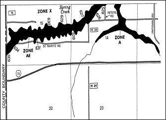 Flood Insurance Rate Maps (FIRMs) provide information to determine if a property is in a 100-year floodplain for regulatory purposes. Updated maps were finalized by the Federal Emergency Management Agency on May 3, 2004. New studies on Jacksonville Branch and Spring Creek and additional flood elevation information on Polecat Creek and Black Branch are provided. Copies of the maps can be reviewed and assistance in interpreting them is available at the Springfield Sangamon County Regional Planning Commission office (room 212 in the County Building) and the Illinois Department of Natural Resources - Office of Water Resources (located at the State Fairgrounds off of Taintor Road). FIRMs are on file at Lincoln Library and the Illinois State Library. Participating communities also have copies. The boundaries of the 100-year floodplain are indicated on these maps by a gray area designated as zone A or, if a base flood elevation is available, as zone AE. White areas are not in a 100-year floodplain and are labeled zone X.
To determine if a property is in the floodplain, utilize the floodplain layer on the Sangamon County GIS Tax Parcel Viewer. A property can be generally located on the Flood Insurance Rate Map by creating a Firmette at the FEMA webpage. General information on flood insurance and flooding can be found on Floodsmart.
BENEFITS OF A NATURAL FLOODPLAIN
When left undisturbed, a floodplain provides storage area for flood waters helping to reduce the height and flow of flooding. Floodplains also provide habitat for a diverse array of plants and animals, control erosion, filter runoff, and recharge groundwater. Sangamon County encourages the preservation of natural areas as a way to decrease the impact of flooding on our community. Particularly important is the fact that when there are no buildings in a floodplain, damage by flooding to human life and property is greatly diminished.
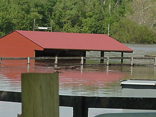
In February 1999, Sangamon County finalized the grant-funded purchase of a 56 acre tract of land at the confluence of the South Fork of the Sangamon River and Sugar Creek. This property had been used as a river camp since the late 1800's and over 40 structures were located there. The entire acreage is in a 100-year floodplain. Consequently the structures and their contents were often damaged or ruined by floodwaters, access to the area was cut off, and contamination of the water occurred. All structures have been removed, the concrete roadway was excavated, and the area is returning to a natural state. Sangamon County has also purchased land and structures that were damaged in the flood of May 2002 and will conduct similar restoration activities with the assistance of Friends of the Sangamon Valley, a charitable organization with experience in restoring and protecting ecologically significant land.
FLOOD ALERTS
Urban and small stream advisory or a flash flood watch: issued when heavy rains which could inundate streams or roadways are predicted. Flash floods can be very dangerous, occurring when water accumulates so rapidly that it cannot be absorbed by the ground or accommodated by storm sewers. Flood waters can move rapidly carrying away anything in its path and can create deep areas of standing water. During a flash flood watch residents should stay aware of the weather and take necessary precautions if conditions worsen.
Flash flood warning: issued when a flash flood is occurring. In addition to the information provided during a flash flood watch, areas of greatest hazard are identified. During periods of a warning, areas subject to flooding should be evacuated and avoided.
Flood warning: issued for the Sangamon River and South Fork of the Sangamon River when heavy rains occurring in areas to the east of Sangamon County will cause local flooding. These usually provide a couple days lead time before flooding reaches our area and local weather forecasts will include this information along with predicted flood heights.
Watches and warnings are sent to radio and television stations by the National Weather Service in Lincoln, Illinois:
- Local Radio Stations
-
- WFMB 1450 AM
- WTAX 1240 AM
- WMAY 970 AM
- NOAA Weather Radio - WXJ75 162.400 kHz
- Local Television Stations
- WAND Channel 17
- WCIA Channel 3
- WICS Channel 20
- Cable Weather Channel 44
DURING AND AFTER A FLOOD
 Do not walk through flowing water. Drowning is the number one cause of flood deaths, mostly during flash floods. Currents can be deceptive, six inches of moving water can knock you off your feet. If you walk in standing water, use a pole or stick to ensure the ground is still there.
 - Do not drive through a flooded area. More people drown in their cars than anywhere else. Don't drive around road barriers because the road or bridge may be washed out.
- Stay away from power lines and electrical wires. The number two flood killer after drowning is electrocution. Electrical current can travel through water. Report downed power lines to the Power Company.
- Report blocked culverts. Road and bridge culverts often become plugged during flooding events diverting water and causing damage to roads and property. Contact the County Highway Department (535-3070) or the Township Road Commissioner.
- Have your electricity turned off by the Power Company. Some appliances, such as television sets, keep electrical charges even after they have been unplugged. Don't use appliances or motors that have gotten wet unless they have been taken apart, cleaned, and dried.
- Look out for animals, especially snakes. Small animals that have been flooded out of their homes may seek shelter in yours. Use a pole or stick to poke and turn things over and scare away small animals. Look before you step. After a flood, the ground and floors are covered with debris including broken bottles and nails. Floors and stairs that have been covered with mud will be slippery.
- Have your gas turned off by the Power Company and be alert for gas leaks. Use a flashlight to inspect for damage. Don't smoke or use candles, lanterns, or open flames unless you know the gas has been turned off and the area has been ventilated.
For more information call the Springfield Sangamon County Regional Planning Commission at 535-3110 or e-mail sscrpc@sangamonil.gov.
Flood Insurance in Sangamon County
Flooding in Sangamon County
Owning and Using Property in the Floodplain
County Floodplain Application WORD or PDF